
Ober Gabelhorn topographic map
Interactive map
Click on the map to display elevation.
About this map
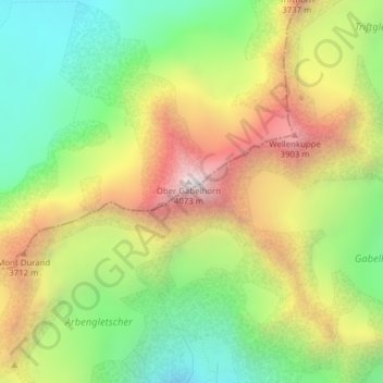
Name: Ober Gabelhorn topographic map, elevation, terrain.
Location: Ober Gabelhorn, Zermatt, Visp, Valais/Wallis, 3920, Switzerland (46.03799 7.66755 46.03809 7.66765)
Average elevation: 10,892 ft
Minimum elevation: 9,003 ft
Maximum elevation: 13,307 ft
Other topographic maps
Click on a map to view its topography, its elevation and its terrain.
Klein Matterhorn
Switzerland > Valais/Wallis > Zermatt
Klein Matterhorn, Zermatt, Visp, Valais/Wallis, 3920, Switzerland
Average elevation: 11,532 ft
Theodulgletscher
Switzerland > Valais/Wallis > Zermatt
Theodulgletscher, Klein Matterhorn, Trockener Steg, Zermatt, Visp, Valais/Wallis, 3920, Switzerland
Average elevation: 10,591 ft
Pennine Alps
Switzerland > Valais/Wallis > Zermatt
Pennine Alps, Zermatt, Visp, Valais/Wallis, 3920, Switzerland
Average elevation: 12,605 ft
Dufourspitze (Monte Rosa)
Switzerland > Valais/Wallis > Zermatt
Dufourspitze (Monte Rosa), Zermatt, Visp, Valais/Wallis, 3920, Switzerland
Average elevation: 13,232 ft
Zumsteinspitze
Switzerland > Valais/Wallis > Zermatt
Zumsteinspitze, Zermatt, Visp, Valais/Wallis, 3920, Switzerland
Average elevation: 13,127 ft