Geolocate

Mapo-gu topographic map

Click on the map to display elevation.

About this map

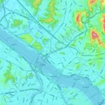
Name: Mapo-gu topographic map, elevation, terrain.

Location: Mapo-gu, Seoul, South Korea (37.53377 126.85363 37.59079 126.96390)

Average elevation: 108 ft

Minimum elevation: -13 ft

Maximum elevation: 922 ft

Other topographic maps

Click on a map to view its topography, its elevation and its terrain.

Cheonggyecheon (Stream)

South Korea > Seoul

Average elevation: 98 ft

Jamsil Hanriver park

South Korea > Seoul

Average elevation: 56 ft

Cheonggyecheon (Stream)

South Korea > Seoul

Average elevation: 105 ft

달터마을

South Korea > Seoul

Average elevation: 177 ft

Haebangchon

South Korea > Seoul

Average elevation: 243 ft

Cheonggyecheon (Stream)

South Korea > Seoul

Average elevation: 98 ft

Ansan Mountain

South Korea > Seoul

Average elevation: 325 ft

Gear up for your next adventure:

🧣Hiking Neck Gaiter - Multi‑use neck protection for outdoor weather
🔥Plasma Lighters - Windproof lighters that work in any weather condition
💧Water Filtration Bottles - Safely drink from streams and lakes while exploring
📻Weather Alert Radios - Stay informed of storm risks while off-the-grid
🧢Sun Protection Hats - Wide-brimmed and UPF-rated hats for high-altitude sun safety

As an Amazon Associate, this site earns from qualifying purchases at no extra cost to you.