
Meter topographic map
Interactive map
Click on the map to display elevation.
About this map
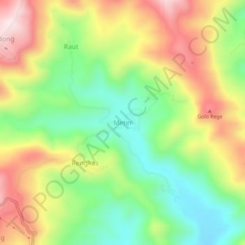
Name: Meter topographic map, elevation, terrain.
Location: Meter, Manggarai Barat, East Nusa Tenggara, Indonesia (-8.61887 120.05710 -8.57887 120.09710)
Average elevation: 1,204 ft
Minimum elevation: 522 ft
Maximum elevation: 2,054 ft
Other topographic maps
Click on a map to view its topography, its elevation and its terrain.
Komodo Island
Indonesia > East Nusa Tenggara > Manggarai Barat > Komodo Village
Komodo Island, Komodo Village, Manggarai Barat, East Nusa Tenggara, Lesser Sunda Islands, Indonesia
Average elevation: 171 ft