
Sant Fruitós de Bages topographic map
Interactive map
Click on the map to display elevation.
About this map
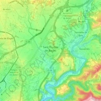
Name: Sant Fruitós de Bages topographic map, elevation, terrain.
Location: Sant Fruitós de Bages, Bages, Barcelona, Catalonië, Spanje (41.72067 1.82841 41.78371 1.90648)
Average elevation: 919 ft
Minimum elevation: 627 ft
Maximum elevation: 1,470 ft
Other topographic maps
Click on a map to view its topography, its elevation and its terrain.
Castellgalí
Spanje > Catalonië > Bages > Castellgalí > Castellgalí
Castellgalí, Bages, Barcelona, Catalonië, 08297, Spanje
Average elevation: 794 ft