
Villa Elisa topographic map
Interactive map
Click on the map to display elevation.
About this map
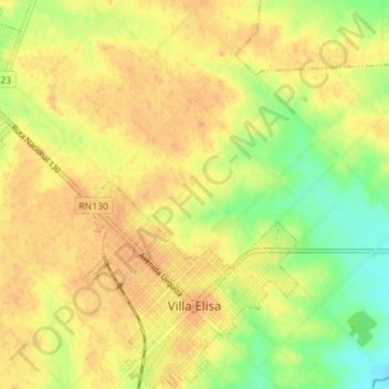
Name: Villa Elisa topographic map, elevation, terrain.
Average elevation: 157 ft
Minimum elevation: 82 ft
Maximum elevation: 197 ft
Other topographic maps
Click on a map to view its topography, its elevation and its terrain.
Junta de Gobierno de Pueblo Liebig
Argentina > Entre Ríos > Distrito Segundo
Junta de Gobierno de Pueblo Liebig, Distrito Segundo, Departamento Colón, Entre Ríos, Argentina
Average elevation: 72 ft