
Falkenberg topographic map
Interactive map
Click on the map to display elevation.
About this map
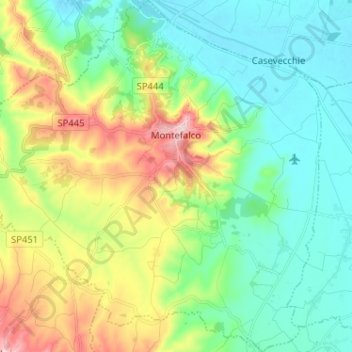
Name: Falkenberg topographic map, elevation, terrain.
Location: Falkenberg, Perugia, Umbrien, 06036, Italien (42.83403 12.57828 42.92799 12.70307)
Average elevation: 928 ft
Minimum elevation: 659 ft
Maximum elevation: 1,542 ft
Auf einem Hügel oberhalb der Flüsse Topino und Clitunno in 431 Meter Höhe gelegen, bietet sich von diesem „Balkon Umbriens“ ein weiter Blick über die Ebene nach Perugia und Assisi, Foligno und Spello, Trevi und Spoleto.
Other topographic maps
Click on a map to view its topography, its elevation and its terrain.
Capitan Loreto
Capitan Loreto, Spello, Perugia, Umbrien, 06038, Italien
Average elevation: 1,007 ft
San Vitale
Italien > Umbrien > Perugia > Assisi
San Vitale, Assisi, Perugia, Umbrien, 06081, Italien
Average elevation: 1,434 ft
Petrognano
Italien > Umbrien > Perugia > Sellano
Petrognano, Sellano, Perugia, Umbrien, 06030, Italien
Average elevation: 2,631 ft
San Pietro
Italien > Umbrien > Perugia > Corciano > San Pietro
San Pietro, Corciano, Perugia, Umbrien, 06073, Italien
Average elevation: 866 ft