
Make a donation
Gear up for your next adventure:
As an Amazon Associate, this site earns from qualifying purchases at no extra cost to you.
Cullinan topographic map
Click on the map to display elevation.
Make a donation
Gear up for your next adventure:
As an Amazon Associate, this site earns from qualifying purchases at no extra cost to you.
Cullinan
Cullinan is situated in the Highveld region of South Africa. The town has an elevation of 1476 m (4842.52 ft) and is located at −25.6709 [latitude in decimal degrees], 28.5236 [longitude in decimal degrees]. The closest city is Pretoria being 40 km (25 mi) away, while Johannesburg is 100 km (62 mi) away.
Make a donation
Gear up for your next adventure:
As an Amazon Associate, this site earns from qualifying purchases at no extra cost to you.
About this map
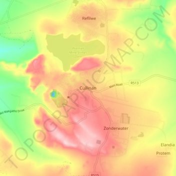
Name: Cullinan topographic map, elevation, terrain.
Average elevation: 4,659 ft
Minimum elevation: 4,245 ft
Maximum elevation: 4,990 ft
Make a donation
Gear up for your next adventure:
As an Amazon Associate, this site earns from qualifying purchases at no extra cost to you.
Other topographic maps
Click on a map to view its topography, its elevation and its terrain.
Hennops
South Africa > Gauteng > City of Tshwane Metropolitan Municipality
Average elevation: 4,872 ft
Bronkhorstspruit Dam
South Africa > Gauteng > City of Tshwane Metropolitan Municipality
Average elevation: 4,797 ft
Rietvlei Dam
South Africa > Gauteng > City of Tshwane Metropolitan Municipality > Doornkloof East
Average elevation: 4,885 ft
Bronkhorstspruit
South Africa > Gauteng > City of Tshwane Metropolitan Municipality
Average elevation: 4,928 ft
Make a donation
Gear up for your next adventure:
As an Amazon Associate, this site earns from qualifying purchases at no extra cost to you.
Centurion Lake
South Africa > Gauteng > City of Tshwane Metropolitan Municipality > Centurion
Average elevation: 4,724 ft
Roodeplaat Dam
South Africa > Gauteng > City of Tshwane Metropolitan Municipality
Average elevation: 3,983 ft
Tshwane Ward 105
South Africa > Gauteng > City of Tshwane Metropolitan Municipality
Average elevation: 4,731 ft
Morula View Park
South Africa > Gauteng > City of Tshwane Metropolitan Municipality
Average elevation: 3,940 ft
Make a donation
Gear up for your next adventure:
As an Amazon Associate, this site earns from qualifying purchases at no extra cost to you.
Wierda Glen
South Africa > Gauteng > City of Tshwane Metropolitan Municipality > Simarlo AH
Average elevation: 4,852 ft
Danville
South Africa > Gauteng > City of Tshwane Metropolitan Municipality > Pretoria
Average elevation: 4,432 ft
Roodeplaat Dam
South Africa > Gauteng > City of Tshwane Metropolitan Municipality
Average elevation: 3,983 ft
Tshwane Ward 91
South Africa > Gauteng > City of Tshwane Metropolitan Municipality
Average elevation: 4,964 ft
Make a donation
Gear up for your next adventure:
As an Amazon Associate, this site earns from qualifying purchases at no extra cost to you.
Tshwane Ward 100
South Africa > Gauteng > City of Tshwane Metropolitan Municipality
Average elevation: 4,619 ft
Tshwane Ward 30
South Africa > Gauteng > City of Tshwane Metropolitan Municipality
Average elevation: 3,957 ft
Tshwane Ward 65
South Africa > Gauteng > City of Tshwane Metropolitan Municipality
Average elevation: 4,879 ft
Tshwane Ward 54
South Africa > Gauteng > City of Tshwane Metropolitan Municipality
Average elevation: 4,222 ft
Make a donation
Gear up for your next adventure:
As an Amazon Associate, this site earns from qualifying purchases at no extra cost to you.
Himalya Street Park
South Africa > Gauteng > City of Tshwane Metropolitan Municipality > Pretoria
Average elevation: 4,777 ft
Hennops
South Africa > Gauteng > City of Tshwane Metropolitan Municipality
Average elevation: 4,872 ft
Tshwane Ward 53
South Africa > Gauteng > City of Tshwane Metropolitan Municipality
Average elevation: 4,304 ft
Bronkhorstspruit Dam
South Africa > Gauteng > City of Tshwane Metropolitan Municipality
Average elevation: 4,797 ft
Make a donation
Gear up for your next adventure:
As an Amazon Associate, this site earns from qualifying purchases at no extra cost to you.