
Argyll topographic map
Interactive map
Click on the map to display elevation.
About this map
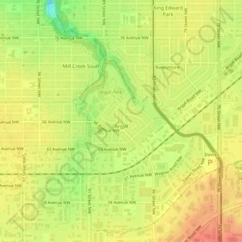
Name: Argyll topographic map, elevation, terrain.
Location: Argyll, Mill Creek South, Division No. 11, Alberta, Canada (53.49988 -113.46687 53.50603 -113.45372)
Average elevation: 2,211 ft
Minimum elevation: 2,110 ft
Maximum elevation: 2,270 ft
Other topographic maps
Click on a map to view its topography, its elevation and its terrain.
Gorman
Canada > Alberta > Division No. 11 > Edmonton
Gorman, Pilot Sound, Edmonton, Division No. 11, Alberta, Canada
Average elevation: 2,156 ft
City of Spruce Grove
Canada > Alberta > Division No. 11
City of Spruce Grove, Division No. 11, Alberta, Canada
Average elevation: 2,293 ft
Athlone
Canada > Alberta > Division No. 11 > Edmonton
Athlone, Northern Mature Area, Edmonton, Division No. 11, Alberta, Canada
Average elevation: 2,224 ft
Edmonton
Canada > Alberta > Division No. 11
Edmonton, Division No. 11, Alberta, Canada
Average elevation: 2,264 ft