
Ellwood topographic map
Interactive map
Click on the map to display elevation.
About this map
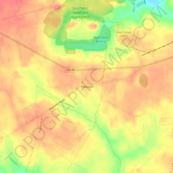
Name: Ellwood topographic map, elevation, terrain.
Location: Ellwood, Augusta, Richmond County, Georgia, United States (33.28431 -82.14929 33.32431 -82.10929)
Average elevation: 390 ft
Minimum elevation: 240 ft
Maximum elevation: 466 ft
Other topographic maps
Click on a map to view its topography, its elevation and its terrain.
Augusta Canal
United States > Georgia > Richmond County > Augusta
Augusta Canal, Augusta, Richmond County, Georgia, United States
Average elevation: 262 ft
Dorchester
United States > Georgia > Richmond County > Augusta
Dorchester, Augusta, Richmond County, Georgia, 30909, United States
Average elevation: 295 ft
Forest Acres
United States > Georgia > Richmond County > Augusta
Forest Acres, Augusta, Richmond County, Georgia, 30904, United States
Average elevation: 220 ft
Fairvale
United States > Georgia > Richmond County > Augusta
Fairvale, Augusta, Richmond County, Georgia, 30906, United States
Average elevation: 184 ft
Berckman Villas
United States > Georgia > Richmond County > Augusta > Berckman Villas
Berckman Villas, Augusta, Richmond County, Georgia, 30904, United States
Average elevation: 285 ft
Fort Gordon
United States > Georgia > Richmond County > Augusta > Fort Gordon
Fort Gordon, Augusta, Richmond County, Georgia, 30905, United States
Average elevation: 446 ft