Geolocate

Cotahuma topographic map

Click on the map to display elevation.

About this map

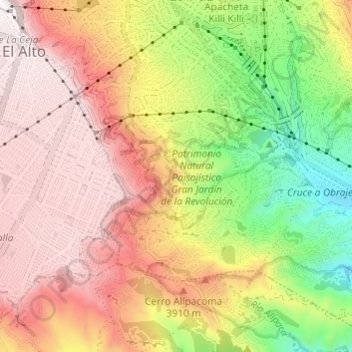
Name: Cotahuma topographic map, elevation, terrain.

Location: Cotahuma, La Paz, Pedro Domingo Murillo, La Paz, Bolivia (-16.55441 -68.15668 -16.49639 -68.11534)

Average elevation: 12,290 ft

Minimum elevation: 10,837 ft

Maximum elevation: 13,465 ft

Other topographic maps

Click on a map to view its topography, its elevation and its terrain.

Chucura Alto

Bolivia > La Paz > Pedro Domingo Murillo > La Paz

Average elevation: 12,808 ft

Plaza Pittsburgh

Bolivia > La Paz > Pedro Domingo Murillo > La Paz

Average elevation: 11,138 ft

Gear up for your next adventure:

🧴Hand Sanitizer - Keep hands clean while hiking
🗻Climbing Gear Basics - Essential gear for beginner climbers
🌡️Handheld Weather Meters - Measure wind, temp, and pressure for safe mountain travel
🪶LED Camping Lantern - Bright lantern for camp lighting
🪶Trail Camera - Capture wildlife on your hikes

As an Amazon Associate, this site earns from qualifying purchases at no extra cost to you.