Geolocate

Monte Agner topographic map

Click on the map to display elevation.

About this map

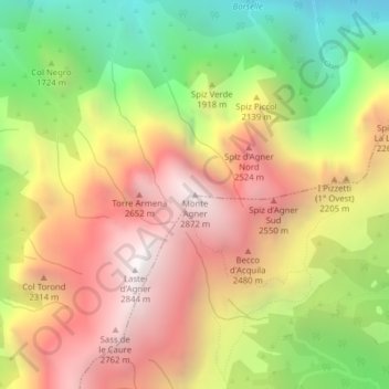
Name: Monte Agner topographic map, elevation, terrain.

Location: Monte Agner, Taibon Agordino, Belluno, Veneto, 32027, Italy (46.27636 11.95266 46.27646 11.95276)

Average elevation: 6,191 ft

Minimum elevation: 2,805 ft

Maximum elevation: 9,285 ft

Gear up for your next adventure:

🧴Hand Sanitizer - Keep hands clean while hiking
📚Navigation Handbooks - Master the art of reading topographic maps and using a compass
🔊Portable Camp Speaker - Music and alerts at camp
🥾Men's Hiking Boots - Durable, waterproof footwear for rugged terrain and steep inclines
🌲Outdoor Survival Books - Best books on survival skills

As an Amazon Associate, this site earns from qualifying purchases at no extra cost to you.