
Sherwood Park topographic map
Interactive map
Click on the map to display elevation.
About this map
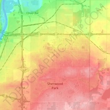
Name: Sherwood Park topographic map, elevation, terrain.
Location: Sherwood Park, Strathcona County, Alberta, Canada (53.50475 -113.40161 53.59950 -113.24652)
Average elevation: 2,267 ft
Minimum elevation: 1,995 ft
Maximum elevation: 2,470 ft
Other topographic maps
Click on a map to view its topography, its elevation and its terrain.
Strathcona Science Provincial Park
Canada > Alberta > Strathcona County > Sherwood Park
Strathcona Science Provincial Park, 17 Street, Sherwood Park, Strathcona County, Alberta, T6S 1E4, Canada
Average elevation: 2,142 ft