
Kingsville topographic map
Interactive map
Click on the map to display elevation.
About this map
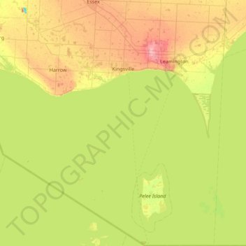
Name: Kingsville topographic map, elevation, terrain.
Location: Kingsville, Essex County, Ontario, Canada (41.67656 -82.84622 42.17728 -82.63568)
Average elevation: 581 ft
Minimum elevation: 466 ft
Maximum elevation: 748 ft
Other topographic maps
Click on a map to view its topography, its elevation and its terrain.
Blytheswood
Canada > Ontario > Essex County > Leamington
Blytheswood, Leamington, Essex County, Ontario, N8H 3V6, Canada
Average elevation: 636 ft
Oakland
Canada > Ontario > Essex County > Leamington
Oakland, Leamington, Essex County, Ontario, N0P 2J0, Canada
Average elevation: 627 ft
Ruthven
Canada > Ontario > Essex County > Kingsville
Ruthven, Kingsville, Essex County, Ontario, N0P 2G0, Canada
Average elevation: 663 ft
Leamington
Canada > Ontario > Essex County
Leamington, Essex County, Southwestern Ontario, Ontario, Canada
Average elevation: 581 ft
Amherstburg
Canada > Ontario > Essex County
Amherstburg, Essex County, Southwestern Ontario, Ontario, Canada
Average elevation: 584 ft