
Champlan topographic map
Interactive map
Click on the map to display elevation.
About this map
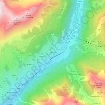
Name: Champlan topographic map, elevation, terrain.
Location: Champlan, Champoluc, Ayas, Vallée d'Aoste, 11020, Italie (45.81056 7.69935 45.85056 7.73935)
Average elevation: 6,394 ft
Minimum elevation: 4,951 ft
Maximum elevation: 8,724 ft
Other topographic maps
Click on a map to view its topography, its elevation and its terrain.
Le Crest
Italie > Vallée d'Aoste > Ayas > Champoluc
Le Crest, Champoluc, Ayas, Vallée d'Aoste, 11020, Italie
Average elevation: 6,732 ft