
Polokwane Ward 6 topographic map
Interactive map
Click on the map to display elevation.
About this map
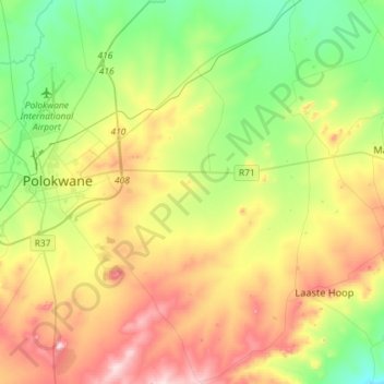
Name: Polokwane Ward 6 topographic map, elevation, terrain.
Location: Polokwane Ward 6, Polokwane Local Municipality, Limpopo, RSA (-24.04571 29.40107 -23.78105 29.68612)
Average elevation: 4,272 ft
Minimum elevation: 3,743 ft
Maximum elevation: 5,095 ft
Other topographic maps
Click on a map to view its topography, its elevation and its terrain.
Polokwane Local Municipality
RSA > Limpopo > Polokwane Local Municipality
Polokwane Local Municipality, Limpopo, RSA
Average elevation: 4,190 ft