
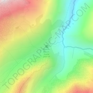
Martin-Busch-Hütte topographic map
Interactive map
Click on the map to display elevation.
About this map
Name: Martin-Busch-Hütte topographic map, elevation, terrain.
Average elevation: 8,796 ft
Minimum elevation: 7,306 ft
Maximum elevation: 10,978 ft
Other topographic maps
Click on a map to view its topography, its elevation and its terrain.
Wildspitze
Autriche > Tyrol > Bezirk Imst > Gemeinde Sölden
Wildspitze, Gemeinde Sölden, Bezirk Imst, Tyrol, 6458, Autriche
Average elevation: 10,774 ft
Zuckerhütl
Autriche > Tyrol > Bezirk Imst > Gemeinde Sölden
Zuckerhütl, Gemeinde Sölden, Bezirk Imst, Tyrol, Autriche
Average elevation: 10,190 ft
Hochjoch-Hospiz
Autriche > Tyrol > Bezirk Imst > Gemeinde Sölden
Hochjoch-Hospiz, 404, Cyprian-Granbichler-Weg, Gemeinde Sölden, Bezirk Imst, Tyrol, 6458, Autriche
Average elevation: 8,517 ft
Vernagthütte
Autriche > Tyrol > Bezirk Imst > Gemeinde Sölden
Vernagthütte, 402, Hütten Vent, Gemeinde Sölden, Bezirk Imst, Tyrol, 6458, Autriche
Average elevation: 9,347 ft