
Zomba topographic map
Interactive map
Click on the map to display elevation.
About this map
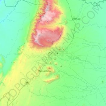
Name: Zomba topographic map, elevation, terrain.
Location: Zomba, Southern Region, Malawi, Malawi (-15.54632 35.16683 -15.22632 35.48683)
Average elevation: 2,917 ft
Minimum elevation: 1,598 ft
Maximum elevation: 6,801 ft
Other topographic maps
Click on a map to view its topography, its elevation and its terrain.
Lake Chilwa
Lake Chilwa, Zomba, Southern Region, Malawi
Average elevation: 2,123 ft