
Hayden Glacier topographic map
Interactive map
Click on the map to display elevation.
About this map
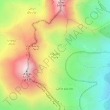
Name: Hayden Glacier topographic map, elevation, terrain.
Average elevation: 8,340 ft
Minimum elevation: 6,952 ft
Maximum elevation: 9,993 ft
Other topographic maps
Click on a map to view its topography, its elevation and its terrain.
Sandy Glacier
Sandy Glacier, Yocum Ridge Trail #771, Clackamas County, Oregon, USA
Average elevation: 7,759 ft
McKenzie Bridge
USA > Oregon > McKenzie Bridge
McKenzie Bridge, Lane County, Oregon, 97413, USA
Average elevation: 1,709 ft
Zigzag Glacier
Zigzag Glacier, Mountaineer Trail #798, Clackamas County, Oregon, USA
Average elevation: 8,596 ft
Waldo Glacier
Waldo Glacier, Pacific Crest Trail, Jefferson County, Oregon, USA
Average elevation: 7,717 ft
Jefferson Park Glacier
Jefferson Park Glacier, Pacific Crest Trail, Jefferson County, Oregon, USA
Average elevation: 7,943 ft
Glisan Glacier
Glisan Glacier, McNeil Point Trail #600M, Hood River County, Oregon, USA
Average elevation: 6,844 ft
Three Fingered Jack
Three Fingered Jack, Linn County, Oregon, USA
Average elevation: 6,171 ft
Thayer Glacier
Thayer Glacier, climber's trail, Deschutes County, Oregon, USA
Average elevation: 7,949 ft
Coalman Glacier
Coalman Glacier, Cooper Spur Trail #600B, Hood River County, Oregon, USA
Average elevation: 8,950 ft
Irving Glacier
Irving Glacier, Camp Lake Trail, Deschutes County, Oregon, USA
Average elevation: 7,690 ft
Crook Glacier
Crook Glacier, Broken Top NW Ridge route, Deschutes County, Oregon, USA
Average elevation: 7,700 ft
Linn Glacier
Linn Glacier, Pacific Crest Trail, Deschutes County, Oregon, USA
Average elevation: 7,740 ft
Villard Glacier
Villard Glacier, climber's trail, Deschutes County, Oregon, USA
Average elevation: 8,031 ft
Palmer Glacier
Palmer Glacier, Mountaineer Trail #798, Clackamas County, Oregon, USA
Average elevation: 7,953 ft
Reid Glacier
Reid Glacier, Yocum Ridge Trail #771, Clackamas County, Oregon, USA
Average elevation: 7,907 ft
Elkhorn Mountains
Elkhorn Mountains, Baker County, Oregon, USA
Average elevation: 7,418 ft
Prouty Glacier
Prouty Glacier, South Sister Climber Trail #36, Deschutes County, Oregon, USA
Average elevation: 8,494 ft
Lost Creek Glacier
Lost Creek Glacier, South Sister Climber Trail #36, Deschutes County, Oregon, USA
Average elevation: 7,972 ft
Skinner Glacier
Skinner Glacier, South Sister Climber Trail #36, Deschutes County, Oregon, USA
Average elevation: 8,136 ft
Newton Clark Glacier
Newton Clark Glacier, Cooper Spur Trail #600B, Hood River County, Oregon, USA
Average elevation: 8,494 ft
Langille Glacier
Langille Glacier, Eliot west moraine, Hood River County, Oregon, USA
Average elevation: 7,103 ft
Lathrop Glacier
Lathrop Glacier, Mt. Thielsen climber's trail, Douglas County, Oregon, USA
Average elevation: 7,333 ft
Eugene Glacier
Eugene Glacier, South Sister Climber Trail #36, Deschutes County, Oregon, USA
Average elevation: 8,159 ft
Renfrew Glacier
Renfrew Glacier, climber's trail, Deschutes County, Oregon, USA
Average elevation: 8,327 ft
Diller Glacier
Diller Glacier, climber's trail, Deschutes County, Oregon, USA
Average elevation: 7,927 ft
Milk Creek Glacier
Milk Creek Glacier, Pacific Crest Trail, Jefferson County, Oregon, USA
Average elevation: 8,228 ft
White River Glacier
White River Glacier, Mountaineer Trail #798, Clackamas County, Oregon, USA
Average elevation: 8,278 ft
Eliot Glacier
Eliot Glacier, Eliot west moraine, Hood River County, Oregon, USA
Average elevation: 7,598 ft
Clark Glacier
Clark Glacier, South Sister Climber Trail #36, Deschutes County, Oregon, USA
Average elevation: 8,458 ft