
Arusha topographic map
Interactive map
Click on the map to display elevation.
About this map
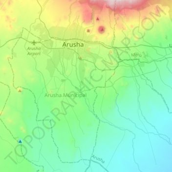
Name: Arusha topographic map, elevation, terrain.
Location: Arusha, Northern Zone, 23210, Tanzanie (-3.57321 36.59996 -3.29941 36.80406)
Average elevation: 4,190 ft
Minimum elevation: 3,140 ft
Maximum elevation: 7,628 ft
Other topographic maps
Click on a map to view its topography, its elevation and its terrain.
Lac Magadi
Lac Magadi, Seneto Descent Road, Kimba, Ngorongoro, Arusha, Northern Zone, Tanzanie
Average elevation: 5,686 ft
Mount Meru
Mount Meru, Arumeru, Arusha, Northern Zone, Tanzanie
Average elevation: 12,743 ft
Ndutu Ranger Post
Ndutu Ranger Post, Ngorongoro, Arusha, Northern Zone, Tanzanie
Average elevation: 5,302 ft
Mt Kitumbeine
Mt Kitumbeine, Monduli, Arusha, Northern Zone, Tanzanie
Average elevation: 8,839 ft