
Spandau topographic map
Interactive map
Click on the map to display elevation.
About this map
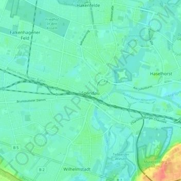
Name: Spandau topographic map, elevation, terrain.
Location: Spandau, Berlin, Germany (52.51750 13.16238 52.55552 13.24772)
Average elevation: 118 ft
Minimum elevation: 85 ft
Maximum elevation: 256 ft
Other topographic maps
Click on a map to view its topography, its elevation and its terrain.
Battle of Berlin
Battle of Berlin, Gertrud-Kolmar-Straße, Dorotheenstadt, Mitte, Berlin, 10117, Germany
Average elevation: 128 ft
Friedrichshain-Kreuzberg
Friedrichshain-Kreuzberg, Berlin, Germany
Average elevation: 148 ft
Charlottenburg-Wilmersdorf
Charlottenburg-Wilmersdorf, Berlin, Germany
Average elevation: 144 ft
Friedrichsfelde
Friedrichsfelde, Lichtenberg, Berlin, Germany
Average elevation: 141 ft