
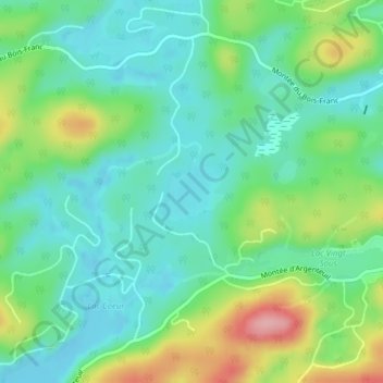
Lac la Grosse topographic map
Interactive map
Click on the map to display elevation.
About this map
Name: Lac la Grosse topographic map, elevation, terrain.
Average elevation: 1,496 ft
Minimum elevation: 1,365 ft
Maximum elevation: 1,798 ft
Other topographic maps
Click on a map to view its topography, its elevation and its terrain.
Lac de la Cabane
Canada > Québec > Les Pays-d'en-Haut > Saint-Adolphe-d'Howard
Lac de la Cabane, Saint-Adolphe-d'Howard, Les Pays-d'en-Haut, Laurentides, Québec, Canada
Average elevation: 1,368 ft
Lac-Gémont
Canada > Québec > Les Pays-d'en-Haut > Saint-Adolphe-d'Howard
Lac-Gémont, Saint-Adolphe-d'Howard, Les Pays-d'en-Haut, Laurentides, Québec, J0T 2B0, Canada
Average elevation: 1,414 ft
Lac Sainte-Marie
Canada > Québec > Les Pays-d'en-Haut > Saint-Adolphe-d'Howard
Lac Sainte-Marie, Saint-Adolphe-d'Howard, Les Pays-d'en-Haut, Laurentides, Québec, Canada
Average elevation: 1,316 ft