
Comuna de Las Rabonas topographic map
Interactive map
Click on the map to display elevation.
About this map
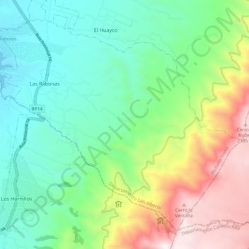
Name: Comuna de Las Rabonas topographic map, elevation, terrain.
Average elevation: 4,469 ft
Minimum elevation: 2,746 ft
Maximum elevation: 8,084 ft
Other topographic maps
Click on a map to view its topography, its elevation and its terrain.
Nono
Argentina > Córdoba > Pedanía Nono
Nono, Municipio de Nono, Pedanía Nono, Departamento San Alberto, Córdoba, X5891, Argentina
Average elevation: 2,900 ft