
Make a donation
Gear up for your next adventure:
As an Amazon Associate, this site earns from qualifying purchases at no extra cost to you.
Fayston topographic map
Click on the map to display elevation.
Make a donation
Gear up for your next adventure:
As an Amazon Associate, this site earns from qualifying purchases at no extra cost to you.
About this map
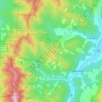
Name: Fayston topographic map, elevation, terrain.
Location: Fayston, Washington County, Vermont, 05673, United States (44.15483 -72.95220 44.27810 -72.78947)
Average elevation: 1,654 ft
Minimum elevation: 627 ft
Maximum elevation: 4,045 ft
Washington County trails, hiking, mountain biking, running and outdoor activities
Make a donation
Gear up for your next adventure:
As an Amazon Associate, this site earns from qualifying purchases at no extra cost to you.
Other topographic maps
Click on a map to view its topography, its elevation and its terrain.
Northfield Center
United States > Vermont > Washington County > Northfield
Average elevation: 1,119 ft
Make a donation
Gear up for your next adventure:
As an Amazon Associate, this site earns from qualifying purchases at no extra cost to you.
Northfield Center
United States > Vermont > Washington County > Northfield
Average elevation: 1,119 ft
South Cabot
United States > Vermont > Washington County > Cabot > South Cabot
Average elevation: 1,575 ft
Make a donation
Gear up for your next adventure:
As an Amazon Associate, this site earns from qualifying purchases at no extra cost to you.