
Arroyo Blanco topographic map
Interactive map
Click on the map to display elevation.
About this map
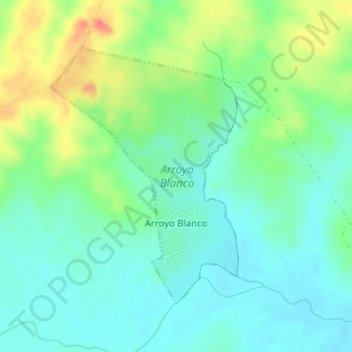
Name: Arroyo Blanco topographic map, elevation, terrain.
Location: Arroyo Blanco, Rivera, 41200, Uruguai (-31.64306 -54.80251 -31.62347 -54.78551)
Average elevation: 548 ft
Minimum elevation: 486 ft
Maximum elevation: 682 ft
Other topographic maps
Click on a map to view its topography, its elevation and its terrain.
Minas de Corrales
Uruguai > Rivera > Minas de Corrales
Minas de Corrales, Rivera, 41100, Uruguai
Average elevation: 489 ft
Cerro Pelado
Uruguai > Rivera > Cerro Pelado
Cerro Pelado, Rivera, 41100, Uruguai
Average elevation: 627 ft