
Saltwater River topographic map
Interactive map
Click on the map to display elevation.
About this map
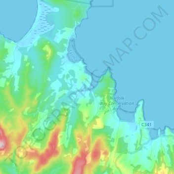
Name: Saltwater River topographic map, elevation, terrain.
Location: Saltwater River, Tasman, Tasmania, Australia (-43.07494 147.67006 -42.97572 147.74572)
Average elevation: 164 ft
Minimum elevation: -3 ft
Maximum elevation: 1,112 ft
Other topographic maps
Click on a map to view its topography, its elevation and its terrain.
The Lanterns
The Lanterns, Tasman, Tasmania, Australia
Average elevation: 33 ft
Smooth Island
Smooth Island, Tasman, Tasmania, Australia
Average elevation: 3 ft
Tasman Peninsula
Australia > Tasmania > Tasman > Fortescue
Tasman Peninsula, Fortescue, Tasman, Tasmania, 7180, Australia
Average elevation: 548 ft
Eaglehawk Neck
Australia > Tasmania > Tasman > Eaglehawk Neck
Eaglehawk Neck, Tasman, Tasmania, 7179, Australia
Average elevation: 397 ft
White Beach
Australia > Tasmania > Tasman > White Beach
White Beach, Tasman, Tasmania, Australia
Average elevation: 148 ft
Wedge Island
Wedge Island, Tasman, Tasmania, Australia
Average elevation: 7 ft
Port Arthur
Port Arthur, Tasman, Tasmania, 7182, Australia
Average elevation: 502 ft
Simmonds Hill
Simmonds Hill, Tasman, Tasmania, Australia
Average elevation: 620 ft