Geolocate

Timber Pines topographic map

Click on the map to display elevation.

About this map

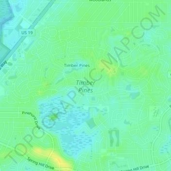
Name: Timber Pines topographic map, elevation, terrain.

Location: Timber Pines, Hernando County, Florida, United States (28.45572 -82.61907 28.47756 -82.58425)

Average elevation: 39 ft

Minimum elevation: 13 ft

Maximum elevation: 79 ft

Hernando County trails, hiking, mountain biking, running and outdoor activities

Gear up for your next adventure:

📌Outdoor GPS Map App - Apps and devices for digital topographic navigation
🪵Folding Camp Saw - Compact saw for wood and campsite work
🔭Compact Binoculars - HD vision for scouting terrain and identifying distant landmarks
📦Gear Storage Bags - Organize and protect outdoor equipment
🖼️Topo Map Wall Art - Decorative topographic prints of famous peaks and regions

As an Amazon Associate, this site earns from qualifying purchases at no extra cost to you.