
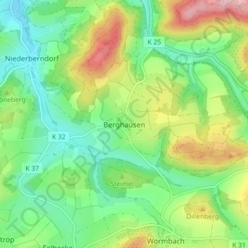
Berghausen topographic map
Interactive map
Click on the map to display elevation.
About this map
Name: Berghausen topographic map, elevation, terrain.
Average elevation: 1,342 ft
Minimum elevation: 1,099 ft
Maximum elevation: 1,785 ft
Other topographic maps
Click on a map to view its topography, its elevation and its terrain.
Altenilpe
Duitsland > Noordrijn-Westfalen > Hochsauerlandkreis > Schmallenberg
Altenilpe, Schmallenberg, Hochsauerlandkreis, Noordrijn-Westfalen, 57392, Duitsland
Average elevation: 1,594 ft
Eben
Duitsland > Noordrijn-Westfalen > Hochsauerlandkreis > Schmallenberg
Eben, Schmallenberg, Hochsauerlandkreis, Noordrijn-Westfalen, Duitsland
Average elevation: 1,565 ft
Oberkirchen
Duitsland > Noordrijn-Westfalen > Hochsauerlandkreis > Schmallenberg > Oberkirchen
Oberkirchen, Schmallenberg, Hochsauerlandkreis, Noordrijn-Westfalen, 57392, Duitsland
Average elevation: 1,739 ft
Bad Fredeburg
Duitsland > Noordrijn-Westfalen > Hochsauerlandkreis > Schmallenberg
Bad Fredeburg, Schmallenberg, Hochsauerlandkreis, Noordrijn-Westfalen, 57392, Duitsland
Average elevation: 1,663 ft
Jagdhaus
Duitsland > Noordrijn-Westfalen > Hochsauerlandkreis > Schmallenberg > Jagdhaus
Jagdhaus, Schmallenberg, Hochsauerlandkreis, Noordrijn-Westfalen, Duitsland
Average elevation: 1,844 ft
Gleidorf
Duitsland > Noordrijn-Westfalen > Hochsauerlandkreis > Schmallenberg > Gleidorf
Gleidorf, Schmallenberg, Hochsauerlandkreis, Noordrijn-Westfalen, 57392, Duitsland
Average elevation: 1,486 ft