
Utrala topographic map
Interactive map
Click on the map to display elevation.
About this map
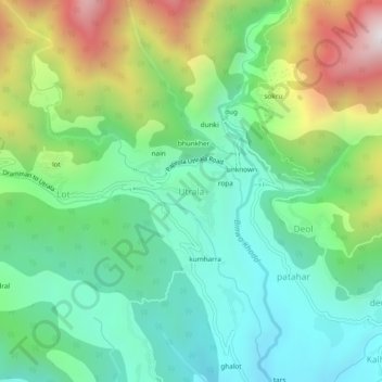
Name: Utrala topographic map, elevation, terrain.
Location: Utrala, Baijnath, Kangra, Himachal Pradesh, India (32.08534 76.62824 32.12534 76.66824)
Average elevation: 4,977 ft
Minimum elevation: 3,717 ft
Maximum elevation: 7,677 ft
Other topographic maps
Click on a map to view its topography, its elevation and its terrain.
Deol
India > Himachal Pradesh > Baijnath
Deol, Baijnath, Kangra, Himachal Pradesh, India
Average elevation: 4,908 ft
Sansal
India > Himachal Pradesh > Baijnath
Sansal, Baijnath, Kangra, Himachal Pradesh, 176077, India
Average elevation: 4,888 ft
Bir
India > Himachal Pradesh > Baijnath
Bir, Baijnath, Kangra, Himachal Pradesh, 176077, India
Average elevation: 5,341 ft
Billing
India > Himachal Pradesh > Baijnath
Billing, Baijnath, Kangra, Himachal Pradesh, 176077, India
Average elevation: 6,936 ft