
Duns Tew topographic map
Interactive map
Click on the map to display elevation.
About this map
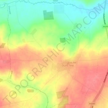
Name: Duns Tew topographic map, elevation, terrain.
Average elevation: 410 ft
Minimum elevation: 272 ft
Maximum elevation: 518 ft
Other topographic maps
Click on a map to view its topography, its elevation and its terrain.
Hornton
United Kingdom > England > Oxfordshire > Cherwell District
Hornton, Cherwell District, Oxfordshire, England, United Kingdom
Average elevation: 564 ft
Juniper Hill
United Kingdom > England > Oxfordshire > Cherwell District > Cottisford
Juniper Hill, Cottisford, Cherwell District, Oxfordshire, England, NN13 5RN, United Kingdom
Average elevation: 413 ft
Bletchingdon
United Kingdom > England > Oxfordshire > Cherwell District
Bletchingdon, Cherwell District, Oxfordshire, England, United Kingdom
Average elevation: 249 ft
Bicester
United Kingdom > England > Oxfordshire > Cherwell District
Bicester, Cherwell District, Oxfordshire, England, United Kingdom
Average elevation: 249 ft
Banbury
United Kingdom > England > Oxfordshire > Cherwell District
Banbury, Cherwell District, Oxfordshire, England, United Kingdom
Average elevation: 381 ft