
Petworth topographic map
Click on the map to display elevation.
About this map
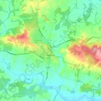
Name: Petworth topographic map, elevation, terrain.
Location: Petworth, Chichester, West Sussex, England, United Kingdom (50.95413 -0.64124 51.02489 -0.55730)
Average elevation: 151 ft
Minimum elevation: 7 ft
Maximum elevation: 509 ft
Other topographic maps
Click on a map to view its topography, its elevation and its terrain.
Donnington Park
United Kingdom > England > West Sussex > Chichester > Apuldram
Average elevation: 26 ft