
Bongdeok-dong topographic map
Interactive map
Click on the map to display elevation.
About this map
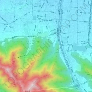
Name: Bongdeok-dong topographic map, elevation, terrain.
Location: Bongdeok-dong, Nam-gu, Daegu, South Korea (35.80680 128.58197 35.85019 128.60777)
Average elevation: 610 ft
Minimum elevation: 171 ft
Maximum elevation: 2,103 ft
Other topographic maps
Click on a map to view its topography, its elevation and its terrain.
Daemyeong-dong
South Korea > Daegu > Daemyeong-dong
Daemyeong-dong, Nam-gu, Daegu, South Korea
Average elevation: 509 ft