
Cafayate topographic map
Interactive map
Click on the map to display elevation.
About this map
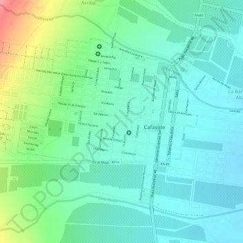
Name: Cafayate topographic map, elevation, terrain.
Location: Cafayate, Salta, A4427AHB, Argentina (-26.08157 -65.99809 -26.06313 -65.97075)
Average elevation: 5,358 ft
Minimum elevation: 5,259 ft
Maximum elevation: 5,604 ft
Other topographic maps
Click on a map to view its topography, its elevation and its terrain.
Cortaderas
Argentina > Salta > Cortaderas
Cortaderas, Municipio Isla de Cañas, Departamento Iruya, Salta, Argentina
Average elevation: 3,379 ft