
Watton topographic map
Click on the map to display elevation.
About this map
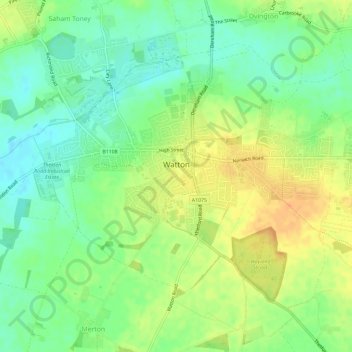
Name: Watton topographic map, elevation, terrain.
Location: Watton, Breckland District, Norfolk, England, United Kingdom (52.55542 0.80280 52.58211 0.86088)
Average elevation: 157 ft
Minimum elevation: 105 ft
Maximum elevation: 217 ft
Other topographic maps
Click on a map to view its topography, its elevation and its terrain.
Saham Hills
United Kingdom > England > Norfolk > Breckland District > Saham Toney
Average elevation: 200 ft
Haverscroft Street
United Kingdom > England > Norfolk > Breckland District > Attleborough
Average elevation: 112 ft
Stonebridge
United Kingdom > England > Norfolk > Breckland District > East Wretham
Average elevation: 125 ft
Thorpe Row
United Kingdom > England > Norfolk > Breckland District > Thorpe Row
Average elevation: 226 ft
Moat
United Kingdom > England > Norfolk > Breckland District > Old Buckenham
Average elevation: 167 ft
Southburgh
United Kingdom > England > Norfolk > Breckland District > Cranworth > Southburgh
Average elevation: 180 ft
Dam Green
United Kingdom > England > Norfolk > Breckland District > Kenninghall
Average elevation: 151 ft