
Ljubljana topographic map
Interactive map
Click on the map to display elevation.
About this map
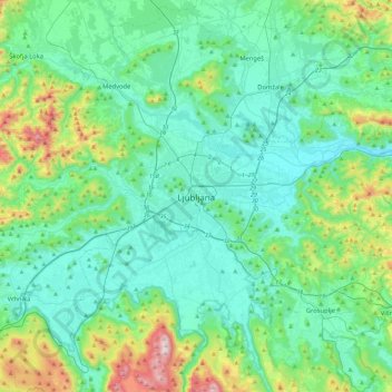
Name: Ljubljana topographic map, elevation, terrain.
Location: Ljubljana, Upravna Enota Ljubljana, 1000, Slovenia (45.88998 14.34686 46.20998 14.66686)
Average elevation: 1,352 ft
Minimum elevation: 823 ft
Maximum elevation: 3,589 ft
Ljubljana has an elevation of 295 meters (968 ft) The city centre, located along the Ljubljanica River, has an elevation of 298 meters (978 ft). Ljubljana Castle, which sits atop Castle Hill (Grajski grič) south of the city centre, has an elevation of 366 meters (1,201 ft). The highest point of the city, called Grmada, reaches 676 meters (2,218 ft), 3 meters (9.8 ft) more than the nearby Mount Saint Mary (Šmarna gora) peak, a popular hiking destination. These are located in the northern part of the city.
Other topographic maps
Click on a map to view its topography, its elevation and its terrain.