
Larraun topographic map
Interactive map
Click on the map to display elevation.
About this map
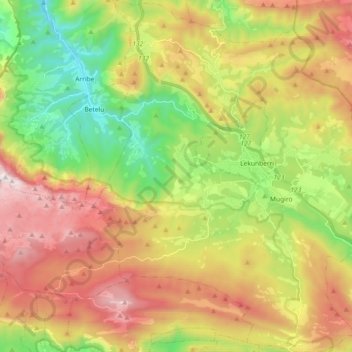
Name: Larraun topographic map, elevation, terrain.
Location: Larraun, Larraun-Leitzaldea, 31879, Espagne (42.93361 -1.98054 43.06675 -1.83179)
Average elevation: 2,457 ft
Minimum elevation: 643 ft
Maximum elevation: 4,659 ft
Other topographic maps
Click on a map to view its topography, its elevation and its terrain.
Goiko Herri
Espagne > Larraun-Leitzaldea > Arano
Goiko Herri, Arano, Larraun-Leitzaldea, 31754, Espagne
Average elevation: 1,053 ft