
Make a donation
Gear up for your next adventure:
As an Amazon Associate, this site earns from qualifying purchases at no extra cost to you.
Valencia topographic map
Click on the map to display elevation.
Make a donation
Gear up for your next adventure:
As an Amazon Associate, this site earns from qualifying purchases at no extra cost to you.
Valencia
The maximum of precipitation occurs in the Autumn, coinciding with the time of the year when cold drop (gota fría) episodes of heavy rainfall—associated to cut-off low pressure systems at high altitude— are common along the Western mediterranean coast. The year-on-year variability in precipitation may be, however, considerable.
Make a donation
Gear up for your next adventure:
As an Amazon Associate, this site earns from qualifying purchases at no extra cost to you.
About this map
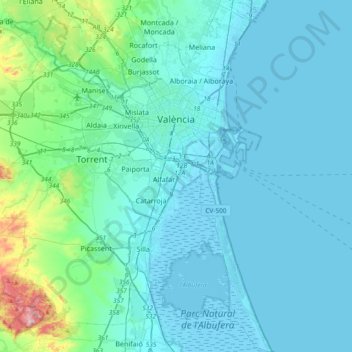
Name: Valencia topographic map, elevation, terrain.
Average elevation: 121 ft
Minimum elevation: -20 ft
Maximum elevation: 1,135 ft
Make a donation
Gear up for your next adventure:
As an Amazon Associate, this site earns from qualifying purchases at no extra cost to you.
Other topographic maps
Click on a map to view its topography, its elevation and its terrain.
Platja del Cabanyal - Les Arenes
Spain > Valencian Community > Comarca de València > Valencia
Average elevation: 7 ft