
Fuentemilanos topographic map
Interactive map
Click on the map to display elevation.
About this map
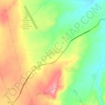
Name: Fuentemilanos topographic map, elevation, terrain.
Location: Fuentemilanos, Ségovie, Castille-et-León, Espagne (40.85490 -4.24786 40.89490 -4.20786)
Average elevation: 3,307 ft
Minimum elevation: 3,091 ft
Maximum elevation: 3,530 ft
Other topographic maps
Click on a map to view its topography, its elevation and its terrain.
La Malija
Espagne > Castille-et-León > Ségovie
La Malija, Ségovie, Castille-et-León, Espagne
Average elevation: 3,340 ft