Geolocate

Dufur topographic map

Click on the map to display elevation.

About this map
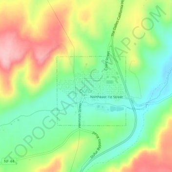
Name: Dufur topographic map, elevation, terrain.

Location: Dufur, Wasco County, Oregon, 97021, United States (45.44765 -121.13678 45.46014 -121.11657)

Average elevation: 1,460 ft

Minimum elevation: 1,243 ft

Maximum elevation: 1,759 ft

Wasco County trails, hiking, mountain biking, running and outdoor activities

Other topographic maps

Click on a map to view its topography, its elevation and its terrain.

Tygh Valley

United States > Oregon > Wasco County > Tygh Valley

Average elevation: 1,302 ft

Frog Lake

United States > Oregon > Wasco County

Average elevation: 4,154 ft

Dant

United States > Oregon > Wasco County

Average elevation: 1,759 ft

Pine Grove

United States > Oregon > Wasco County

Average elevation: 2,339 ft

Chenowith

United States > Oregon > Wasco County

Average elevation: 633 ft

Gear up for your next adventure:

🚗GPS Dash Cams - Record your scenic drives through mountain passes and canyons
🔥Camping Stove - Portable stove for camping and backcountry cooking
📶Vehicle Signal Boosters - Improve reception in rural areas while driving to trailheads
🛰️Satellite Messengers - Emergency SOS and two-way messaging for off-grid adventures
🛌Ultralight Sleeping Bags - Compact down bags for cold nights in the wilderness

As an Amazon Associate, this site earns from qualifying purchases at no extra cost to you.