Geolocate

Callabiana topographic map

Click on the map to display elevation.

About this map

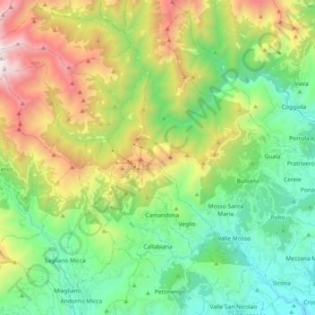
Name: Callabiana topographic map, elevation, terrain.

Location: Callabiana, Biella, Piedmont, Italy (45.62008 7.92390 45.71468 8.10655)

Average elevation: 3,314 ft

Minimum elevation: 1,047 ft

Maximum elevation: 7,828 ft

Other topographic maps

Click on a map to view its topography, its elevation and its terrain.

Ravizza

Italy > Piedmont > Biella > Andorno Micca

Average elevation: 2,241 ft

Gear up for your next adventure:

🔊Portable Camp Speaker - Music and alerts at camp
🌄Hiking Binoculars - Compact binoculars for scenic views and trail spotting
🏔️Mountain Trail Maps - High‑detail maps for popular peaks
📖Nature Tracking Books - Learn to track wildlife and terrain
🪓Survival Multi‑Tool - Versatile tool for camp and trail tasks

As an Amazon Associate, this site earns from qualifying purchases at no extra cost to you.