
Make a donation
Gear up for your next adventure:
As an Amazon Associate, this site earns from qualifying purchases at no extra cost to you.
Cambrils topographic map
Click on the map to display elevation.
Make a donation
Gear up for your next adventure:
As an Amazon Associate, this site earns from qualifying purchases at no extra cost to you.
About this map
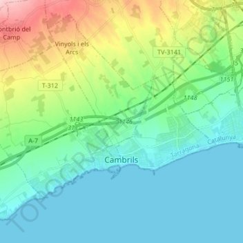
Name: Cambrils topographic map, elevation, terrain.
Location: Cambrils, Baix Camp, Tarragona, Catalonia, 43850, Spain (41.05229 0.98526 41.11524 1.11784)
Average elevation: 138 ft
Minimum elevation: 0 ft
Maximum elevation: 558 ft
Make a donation
Gear up for your next adventure:
As an Amazon Associate, this site earns from qualifying purchases at no extra cost to you.
Other topographic maps
Click on a map to view its topography, its elevation and its terrain.
Almoster
Spain > Catalonia > Baix Camp > Almoster
Its climate is dry Mediterranean, with low rainfall in the summer and occasionally heavy rainfall in spring and autumn. The driest month is July, with an average rainfall of only 15 mm, and September is usually the wettest, with an average of about 75 mm. The average annual precipitation barely reaches 500 mm.…
Average elevation: 948 ft