
Rouken Glen Park topographic map
Interactive map
Click on the map to display elevation.
About this map
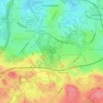
Name: Rouken Glen Park topographic map, elevation, terrain.
Average elevation: 213 ft
Minimum elevation: 79 ft
Maximum elevation: 394 ft
Other topographic maps
Click on a map to view its topography, its elevation and its terrain.
Thornliebank
United Kingdom > Scotland > East Renfrewshire > Thornliebank
Thornliebank, East Renfrewshire, Scotland, G46 7RX, United Kingdom
Average elevation: 194 ft