
Sketty topographic map
Interactive map
Click on the map to display elevation.
About this map
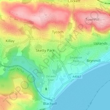
Name: Sketty topographic map, elevation, terrain.
Location: Sketty, Swansea, Wales, United Kingdom (51.59486 -4.01320 51.63406 -3.96735)
Average elevation: 226 ft
Minimum elevation: -3 ft
Maximum elevation: 577 ft
Other topographic maps
Click on a map to view its topography, its elevation and its terrain.
Singleton Park
United Kingdom > Wales > Swansea > Swansea
Singleton Park, Sketty, Swansea, Wales, United Kingdom
Average elevation: 131 ft
Kilvey Hill
United Kingdom > Wales > Swansea > Swansea
Kilvey Hill, Swansea, Wales, SA1 8ED, United Kingdom
Average elevation: 164 ft
Birchgrove
United Kingdom > Wales > Swansea > Swansea
Birchgrove, Swansea, Wales, United Kingdom
Average elevation: 338 ft