
Volgré topographic map
Interactive map
Click on the map to display elevation.
About this map
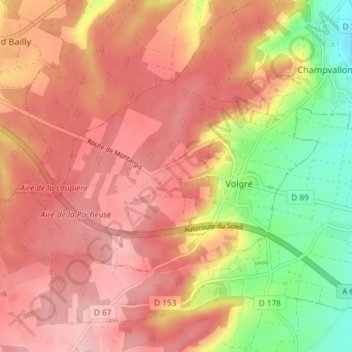
Name: Volgré topographic map, elevation, terrain.
Average elevation: 604 ft
Minimum elevation: 295 ft
Maximum elevation: 784 ft
Other topographic maps
Click on a map to view its topography, its elevation and its terrain.
Aillant-sur-Tholon
France > Bourgogne-Franche-Comté > Yonne > Montholon
Aillant-sur-Tholon, Montholon, Auxerre, Yonne, Bourgogne-Franche-Comté, France métropolitaine, 89110, France
Average elevation: 577 ft
Champvallon
France > Bourgogne-Franche-Comté > Yonne > Montholon
Champvallon, Montholon, Auxerre, Yonne, Bourgogne-Franche-Comté, France métropolitaine, 89710, France
Average elevation: 456 ft