
Plounévez-Quintin topographic map
Interactive map
Click on the map to display elevation.
About this map
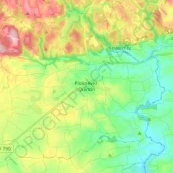
Name: Plounévez-Quintin topographic map, elevation, terrain.
Average elevation: 643 ft
Minimum elevation: 433 ft
Maximum elevation: 994 ft
Other topographic maps
Click on a map to view its topography, its elevation and its terrain.
Botcol
France > Brittany > Côtes-d'Armor > Plounévez-Quintin > Botcol
Botcol, Plounévez-Quintin, Guingamp, Côtes-d'Armor, Brittany, Metropolitan France, 22110, France
Average elevation: 640 ft