
Lac à Lauzon topographic map
Interactive map
Click on the map to display elevation.
About this map
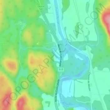
Name: Lac à Lauzon topographic map, elevation, terrain.
Average elevation: 787 ft
Minimum elevation: 643 ft
Maximum elevation: 1,106 ft
Other topographic maps
Click on a map to view its topography, its elevation and its terrain.
Lac Marier
Canada > Québec > Les Laurentides > Labelle
Lac Marier, Labelle, Les Laurentides, Laurentides, Québec, Canada
Average elevation: 1,053 ft