
La Yarada topographic map
Interactive map
Click on the map to display elevation.
About this map
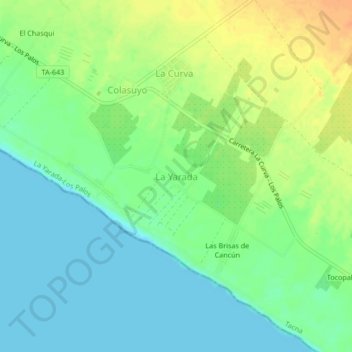
Name: La Yarada topographic map, elevation, terrain.
Location: La Yarada, La Yarada-Los Palos, Tacna, Perú (-18.25394 -70.55076 -18.21394 -70.51076)
Average elevation: 46 ft
Minimum elevation: 0 ft
Maximum elevation: 115 ft
Other topographic maps
Click on a map to view its topography, its elevation and its terrain.
San Martin de Porres
Perú > Tacna > La Yarada-Los Palos
San Martin de Porres, La Yarada-Los Palos, Tacna, Perú
Average elevation: 167 ft
La Yarada-Los Palos
Perú > Tacna > La Yarada-Los Palos
La Yarada-Los Palos, Tacna, Perú
Average elevation: 318 ft