
Labuan Bajo topographic map
Click on the map to display elevation.
About this map
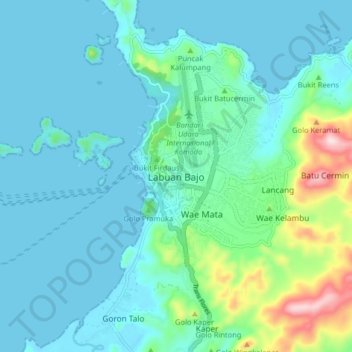
Name: Labuan Bajo topographic map, elevation, terrain.
Average elevation: 194 ft
Minimum elevation: 0 ft
Maximum elevation: 1,171 ft
Other topographic maps
Click on a map to view its topography, its elevation and its terrain.
Komodo Island
Indonesia > East Nusa Tenggara > Manggarai Barat > Komodo Village
Average elevation: 171 ft
Komodo Island
Indonesia > East Nusa Tenggara > Manggarai Barat > Komodo Village
Average elevation: 171 ft
Gili Lawa Darat Island
Indonesia > East Nusa Tenggara > Manggarai Barat > Komodo
Average elevation: 43 ft
Komodo Island
Indonesia > East Nusa Tenggara > Manggarai Barat > Komodo Village
Average elevation: 171 ft
Komodo Island
Indonesia > East Nusa Tenggara > Manggarai Barat > Komodo Village
Average elevation: 171 ft