
山南镇 topographic map
Interactive map
Click on the map to display elevation.
About this map
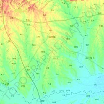
Name: 山南镇 topographic map, elevation, terrain.
Location: 山南镇, 肥西县, 安徽省, 231200, 中国 (31.51961 116.74794 31.68892 116.92891)
Average elevation: 118 ft
Minimum elevation: 36 ft
Maximum elevation: 299 ft
Other topographic maps
Click on a map to view its topography, its elevation and its terrain.