
Ternay topographic map
Interactive map
Click on the map to display elevation.
About this map
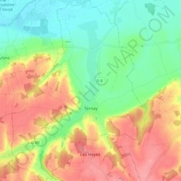
Name: Ternay topographic map, elevation, terrain.
Average elevation: 325 ft
Minimum elevation: 187 ft
Maximum elevation: 482 ft
Other topographic maps
Click on a map to view its topography, its elevation and its terrain.
Plateau de Bel-Air
France > Centre-Val de Loire > Loir-et-Cher > Saint-Ouen > Côte de Bel-Air
Average elevation: 344 ft
La Pente de l'Aigri
France > Centre-Val de Loire > Loir-et-Cher > Saint-Georges-sur-Cher
Average elevation: 325 ft
La Batardière
France > Centre-Val de Loire > Loir-et-Cher > Montrichard Val de Cher
Average elevation: 325 ft
Chouzy
France > Centre-Val de Loire > Loir-et-Cher > La Chapelle-Saint-Martin-en-Plaine
Average elevation: 377 ft
Le Bourg
France > Centre-Val de Loire > Loir-et-Cher > Chaumont-sur-Tharonne
Average elevation: 400 ft