
Porum topographic map
Interactive map
Click on the map to display elevation.
About this map
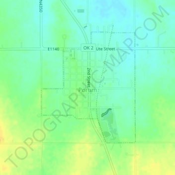
Name: Porum topographic map, elevation, terrain.
Location: Porum, Muskogee County, Oklahoma, 74455, United States (35.34804 -95.27427 35.36513 -95.25648)
Average elevation: 594 ft
Minimum elevation: 561 ft
Maximum elevation: 636 ft
Other topographic maps
Click on a map to view its topography, its elevation and its terrain.
Briartown
United States > Oklahoma > Muskogee County
Briartown, Muskogee County, Oklahoma, 74472, United States
Average elevation: 564 ft
Warner
United States > Oklahoma > Muskogee County
Warner, Muskogee County, Oklahoma, 74469, United States
Average elevation: 571 ft
Braggs
United States > Oklahoma > Muskogee County
Braggs, Muskogee County, Oklahoma, 74423, United States
Average elevation: 571 ft
Muskogee
United States > Oklahoma > Muskogee County
Muskogee, Muskogee County, Oklahoma, United States
Average elevation: 577 ft
Ross Lake
United States > Oklahoma > Muskogee County > Fort Gibson
Ross Lake, Fort Gibson, Muskogee County, Oklahoma, United States
Average elevation: 512 ft
Fort Gibson
United States > Oklahoma > Muskogee County > Fort Gibson
Fort Gibson, Lee Street, Fort Gibson, Muskogee County, Oklahoma, 74434, United States
Average elevation: 531 ft
Muskogee
United States > Oklahoma > Muskogee County > Muskogee
Muskogee, Muskogee County, Oklahoma, 74401, United States
Average elevation: 581 ft
Webbers Falls
United States > Oklahoma > Muskogee County
Webbers Falls, Muskogee County, Oklahoma, 74470, United States
Average elevation: 482 ft